


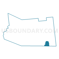
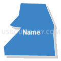
Voting District 110004, Fulton County, New York
About
Outline

Summary
| Unique Area Identifier | 627258 |
| Name | Voting District 110004 |
| County | Fulton County |
| State | New York |
| Area (square miles) | 7.07 |
| Land Area (square miles) | 7.06 |
| Water Area (square miles) | 0.01 |
| % of Land Area | 99.93 |
| % of Water Area | 0.07 |
| Latitude of the Internal Point | 43.00540690 |
| Longtitude of the Internal Point | -74.20406870 |
Maps


Graphs
Select a template below for downloading or customizing gragh for Voting District 110004, Fulton County, New York


Neighbors
Neighoring Voting District (by Name) Neighboring Voting District on the Map
- Voting District 010001, Montgomery County, NY
- Voting District 010005, Montgomery County, NY
- Voting District 020004, Fulton County, NY
- Voting District 080002, Fulton County, NY
- Voting District 080003, Fulton County, NY
- Voting District 110001, Fulton County, NY
- Voting District 110002, Fulton County, NY
Top 10 Neighboring County Subdivision (by Population) Neighboring County Subdivision on the Map
- Mayfield town, Fulton County, NY (6,495)
- Amsterdam town, Montgomery County, NY (5,566)
- Broadalbin town, Fulton County, NY (5,260)
- Perth town, Fulton County, NY (3,646)
Top 10 Neighboring Unified School District (by Population) Neighboring Unified School District on the Map
Top 10 Neighboring State Legislative District Lower Chamber (by Population) Neighboring State Legislative District Lower Chamber on the Map
Top 10 Neighboring State Legislative District Upper Chamber (by Population) Neighboring State Legislative District Upper Chamber on the Map
Top 10 Neighboring 111th Congressional District (by Population) Neighboring 111th Congressional District on the Map
Top 10 Neighboring Census Tract (by Population) Neighboring Census Tract on the Map
- Census Tract 721, Montgomery County, NY (5,566)
- Census Tract 9715, Fulton County, NY (5,260)
- Census Tract 9703, Fulton County, NY (3,781)
- Census Tract 9714, Fulton County, NY (3,646)